File:Saguaro Cacti - Saguaro National Park, AZ - 1935.jpg
From Kook Science

Original file (1,800 × 1,239 pixels, file size: 1.84 MB, MIME type: image/jpeg)
Summary
| Description |
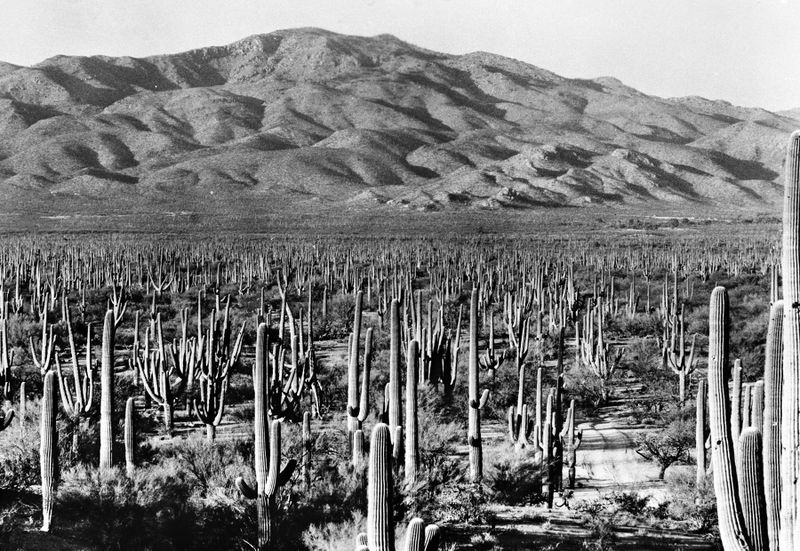
Saguaro National Park, East Unit, Southern Arizona - ca. 1935: This camera station is located on a hill within the newly established Saguaro National Monument near Tucson. The view is northeast toward Agua Caliente Hill and looks down a gentle incline that drains into Tanque Verde Creek. The saguaro stand pictured here is a particularly memorable one because of the many large individuals and absence of small ones. It is an example of the Arizona Uplands at its upper colder elevation limit on level to rolling terrain. The dominant plants here are brittlebush, foothill paloverde, velvet mesquite, and saguaro. In the distance, on the floodplain of Tanque Verde Creek, saguaros become infrequent and mesquite predominates. On the banks of Tanque Verde Creek at right, the large trees are cottonwood and Goodding willow. The elevation is 3,050 feet. (photographer unknown) |
|---|---|
| Source |
https://www.usgs.gov/media/images/saguaro-national-park-east-unit-southern-arizona-ca-1935 |
| Date |
ca. 1935 |
| Author |
U.S. Geological Survey |
| Permission |
Public Domain |
Licensing
| This file has been released into the public domain by the copyright holder, its copyright has expired, or it is ineligible for copyright. |
File history
Click on a date/time to view the file as it appeared at that time.
| Date/Time | Thumbnail | Dimensions | User | Comment | |
|---|---|---|---|---|---|
| current | 12:47, 5 January 2019 | | 1,800 × 1,239 (1.84 MB) | TK (talk | contribs) | {{Information |Description=Saguaro National Park, East Unit, Southern Arizona - ca. 1935: This camera station is located on a hill within the newly established Saguaro National Monument near Tucson. The view is northeast toward Agua Caliente Hill and l... |
You cannot overwrite this file.
File usage
The following page uses this file: