File:Mu's Geographic Location - Churchward - 1926.png
From Kook Science

Size of this preview: 800 × 528 pixels. Other resolution: 2,500 × 1,650 pixels.
Original file (2,500 × 1,650 pixels, file size: 191 KB, MIME type: image/png)
Summary
| Description |
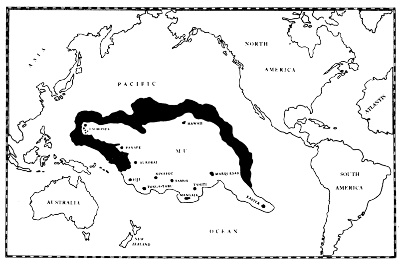
"The Geographic Position of Mu", a b&w map of the Pacific Ocean, including a bordered region constituting Mu, which encompasses the Ladrones, Hawaii, Easter Island, Marquesas, Tahiti, Mangaia, Samoa, Tonga-Tabu (Tongatapu), Ninafou (Niuafoʻou), Fiji, Aurorai (Makatea), and Ponape (Pohnpei). |
|---|---|
| Source |
Churchward, James (1926), The Lost Continent of Mu: the Motherland of Man, New York: W.E. Rudge |
| Date |
1926 |
| Author |
James Churchward |
| Permission |
PD. |
Licensing
| This file has been released into the public domain by the copyright holder, its copyright has expired, or it is ineligible for copyright. |
File history
Click on a date/time to view the file as it appeared at that time.
| Date/Time | Thumbnail | Dimensions | User | Comment | |
|---|---|---|---|---|---|
| current | 20:18, 8 February 2018 | | 2,500 × 1,650 (191 KB) | TK (talk | contribs) | {{Information |description= "The Geographic Position of Mu", a b&w map of the Pacific Ocean, including a bordered region constituting Mu, which encompasses the Ladrones, Hawaii, Easter Island, Marquesas, Tahiti, Mangaia, Samoa, Tonga-Tabu (Tongatap... |
You cannot overwrite this file.
File usage
The following 6 pages use this file:
- Mu
- The Lost Continent of Mu (1926 book)
- File:James Churchward, Lost Continent of Mu (1926) - Map of Mu, p. 38.png (file redirect)
- File:James Churchward, Lost Continent of Mu (1926) - The Geographical Position of Mu, p. 36.jpg (file redirect)
- File:James Churchward, Lost Continent of Mu (1926) - The Geographical Position of Mu, p. 36.png (file redirect)
_-_Map_of_Mu,_p._38.png&redirect=no)
_-_The_Geographical_Position_of_Mu,_p._36.jpg&redirect=no)
_-_The_Geographical_Position_of_Mu,_p._36.png&redirect=no)